Kapa‘a STREAM
Kailua
General Description
Kapa‘a Stream is a short fluvial feature, even by island standards. It is shown on USGS topographic maps as being around 3 km (1.9 mi) long, arising on the southwest slope of Ulumawao, flowing initially southwestward, then turning northward and finally northeastward towards Kawai Nui Marsh. Over that distance, the elevation change is around 180 m (600 ft). The upper part of the stream course is hardly a stream at all, but a gully or swale that is dry and overgrown with vegetation, showing little evidence of water flow that would occur only during heavy rains. Thus, there is no "upper reach" of Kapa‘a Stream.
Middle Reach
The middle reach of Kapa‘a Stream begins about where the channel crosses beneath H-3 in the upper valley. Below this point, water flows intermittently in a steep-sided ditch that appears man-made and is squeezed between the H-3 freeway and the Ameron plant. This feature crosses under the Ameron entrance road in culverts, then parallels the latter on its west side as a deep, narrow ravine.

 Somewhere in the vicinity of the Ameron quarry entrance road crossing (see Photo 1), Kapa‘a stream shows a summer trickle flow and the stream becomes, by definition, perennial; however, even this middle reach flow is interrupted and may cease altogether in extended drought periods. At this point, two-thirds of the elevation drop has been lost. Half of the remainder (about 30 m or 100 vertical feet) occurs as the stream bed crosses under the H-3 for a second time. The stream gradient drops dramatically as Kapa‘a Stream flows out onto a flood plain that represents an upper arm of Kawai Nui Marsh (see Lower Reach below).
- Photo 1
-
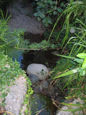
This small plunge pool is one expression of perennial flow in the middle reach of Kapa‘a Stream. Located a short distance downstream from the upper green waste access road, seeps above the escarpment flow into the pool which harbors Pacific prawn (Macrobrachium lar).
Lower Reach
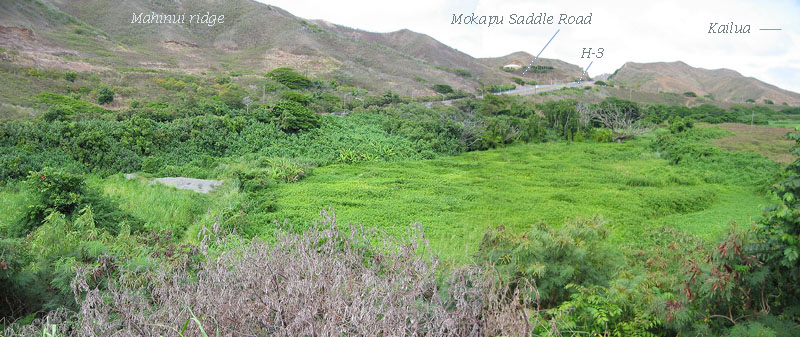
The lower reach of Kapa‘a Stream flows through a much disturbed wetland. An abandoned gravel berm/road that cuts across the valley forces stream flow to one side where the water flows partly within a dense growth of hau (Hibiscus tiliaceus) below the H-3 freeway. The wetland in the center of the valley (see Photo 2) is overgrown with umbrella sedge (Cyperus alternifolius), elephant grass (Pennisetum purpureum), and California grass (Brachiaria mutica).


- Photo 2 (above)
-
The abandoned gravel road cutting across the wetland ends in the gravel berm seen on the left in this composite photograph. The "middle" wetland here is narrowed by an old landfill, seen on the far right side of the photograph. This 3 to 6 m (9 to 18 ft) rise in elevation marks the edge of the first landfill in Kapa‘a Valley.
- Photo 3 (right)
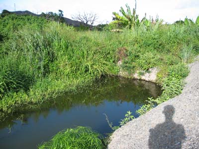
- A pond, resulting from dredging perhaps to remove temporary culverts put in as part of the gravel road, lies just beyond the gravel berm.
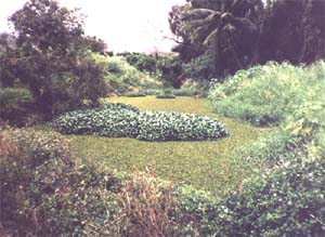
There appears to be multiple small channels of Kapa‘a Stream through the wetland. Most are flood channels, and it is difficult to find flowing water during the summer months anywhere in the dense vegetation. The valley bottom is dominated by elephant grass, which grows to a height of several meters in the moist soil. The stream channels, joined by numerous dry lateral channels draining side slopes, eventually end up in a single pond-like feature filled with water (see WQ Sta. 1), but appearing stagnant most of the time . This pond, after passing beneath Kapaa Quarry Road, extends out into Kawai Nui Marsh. The surface of the pond is usually covered by floating water hyacinth (Eichhornia crassipes) and water fern (Salvinia molesta; see Photo 3).


|
- Photo 4
-
Kapa‘a Stream looking upstream from Kapaa Quarry Road. The pond here is covered by water fern and a large patch of water hyacinth. The latter sometimes covers the entire surface.
|
|
SEE ALSO:
|

![]() Somewhere in the vicinity of the Ameron quarry entrance road crossing (see Photo 1), Kapa‘a stream shows a summer trickle flow and the stream becomes, by definition, perennial; however, even this middle reach flow is interrupted and may cease altogether in extended drought periods. At this point, two-thirds of the elevation drop has been lost. Half of the remainder (about 30 m or 100 vertical feet) occurs as the stream bed crosses under the H-3 for a second time. The stream gradient drops dramatically as Kapa‘a Stream flows out onto a flood plain that represents an upper arm of Kawai Nui Marsh (see Lower Reach below).
Somewhere in the vicinity of the Ameron quarry entrance road crossing (see Photo 1), Kapa‘a stream shows a summer trickle flow and the stream becomes, by definition, perennial; however, even this middle reach flow is interrupted and may cease altogether in extended drought periods. At this point, two-thirds of the elevation drop has been lost. Half of the remainder (about 30 m or 100 vertical feet) occurs as the stream bed crosses under the H-3 for a second time. The stream gradient drops dramatically as Kapa‘a Stream flows out onto a flood plain that represents an upper arm of Kawai Nui Marsh (see Lower Reach below).


